Tremendo monstruo de tormenta sobre la península.
Lunes 17 Junio 2024
Cuando salga al mar, se intensificaría a ciclón tropical. Tiene un 70 % de probabilidad.
<div class="xdj266r x11i5rnm xat24cr x1mh8g0r x1vvkbs x126k92a" style="margin: 0px; overflow-wrap: break-word; white-space-collapse: preserve; font-family: 'Segoe UI Historic', 'Segoe UI', Helvetica, Arial, sans-serif; color: #050505; font-size: 15px;">
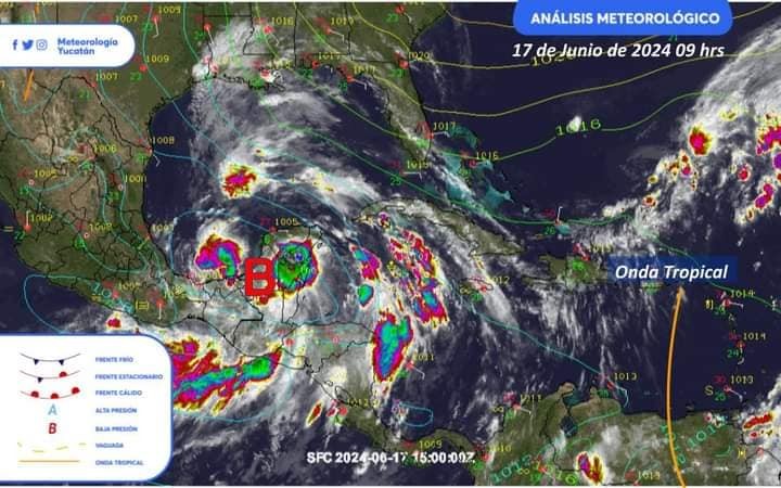
<div dir="auto" style="font-family: inherit;">Tremendo monstruo de tormenta sobre la península.</div>
</div>
<div class="x11i5rnm xat24cr x1mh8g0r x1vvkbs xtlvy1s x126k92a" style="margin: 0.5em 0px 0px; overflow-wrap: break-word; white-space-collapse: preserve; font-family: 'Segoe UI Historic', 'Segoe UI', Helvetica, Arial, sans-serif; color: #050505; font-size: 15px;">
<div dir="auto" style="font-family: inherit;">Un extenso sistema convectivo a mesoescala asociado a la baja presión en vigilancia ciclónica, cubre la mayor parte de la península. Prepárense en <span class="html-span xdj266r x11i5rnm xat24cr x1mh8g0r xexx8yu x4uap5 x18d9i69 xkhd6sd x1hl2dhg x16tdsg8 x1vvkbs" style="margin: 0px; text-align: inherit; overflow-wrap: break-word; padding: 0px; font-family: inherit;"><a class="x1i10hfl xjbqb8w x1ejq31n xd10rxx x1sy0etr x17r0tee x972fbf xcfux6l x1qhh985 xm0m39n x9f619 x1ypdohk xt0psk2 xe8uvvx xdj266r x11i5rnm xat24cr x1mh8g0r xexx8yu x4uap5 x18d9i69 xkhd6sd x16tdsg8 x1hl2dhg xggy1nq x1a2a7pz x1sur9pj xkrqix3 x1fey0fg xo1l8bm" style="cursor: pointer; text-decoration-line: none; outline: none; list-style: none; margin: 0px; text-align: inherit; border-style: none; padding: 0px; border-width: 0px; box-sizing: border-box; background-color: transparent; -webkit-tap-highlight-color: transparent; touch-action: manipulation; display: inline; font-family: inherit;" tabindex="0" href="https://www.facebook.com/hashtag/m%C3%A9rida?__eep__=6&__cft__[0]=AZX6usw9B6cyZx_sXhPB64OQcOEzdMPxfM_zWnU8-UT9go_CiRqTP4GHX3mYJUfZjGcn0fDxOnm8TbKkI8AU07rbjzzM2dcknlmLK9aVCy7zk6jUXo3iyUioAXl_axPRObumoOX2gZwMpYM7Dh2bil2LR445RlkcTumxc57fb6N5fG7pqVtnKZcIvfk4hZI7xMmcMQ6TVIajXSbALfL-A_ru&__tn__=*NK-R">#Mérida</a></span> que se aproxima.</div>
</div>
<div class="x11i5rnm xat24cr x1mh8g0r x1vvkbs xtlvy1s x126k92a" style="margin: 0.5em 0px 0px; overflow-wrap: break-word; white-space-collapse: preserve; font-family: 'Segoe UI Historic', 'Segoe UI', Helvetica, Arial, sans-serif; color: #050505; font-size: 15px;">
<div dir="auto" style="font-family: inherit;">Nuestros análisis meteorológicos muestran baja presión en vigilancia ya más organizada desde superficie hasta niveles superiores. Se ubica al suroeste de Campeche.</div>
</div>
<div class="x11i5rnm xat24cr x1mh8g0r x1vvkbs xtlvy1s x126k92a" style="margin: 0.5em 0px 0px; overflow-wrap: break-word; white-space-collapse: preserve; font-family: 'Segoe UI Historic', 'Segoe UI', Helvetica, Arial, sans-serif; color: #050505; font-size: 15px;">
<div dir="auto" style="font-family: inherit;">Cuando salga al mar, se intensificaría a ciclón tropical. Tiene un 70 % de probabilidad.</div>
</div>
<div class="x11i5rnm xat24cr x1mh8g0r x1vvkbs xtlvy1s x126k92a" style="margin: 0.5em 0px 0px; overflow-wrap: break-word; white-space-collapse: preserve; font-family: 'Segoe UI Historic', 'Segoe UI', Helvetica, Arial, sans-serif; color: #050505; font-size: 15px;">
<div dir="auto" style="font-family: inherit;">Fuente:</div>
<div dir="auto" style="font-family: inherit;">Meteorología Yucatán</div>
</div>