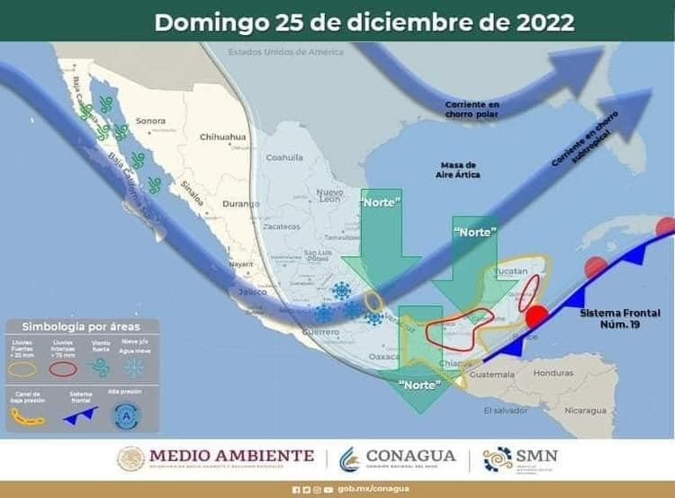
Continuará el frío en las próximas horas en Quintana Roo
Domingo 25 Diciembre 2022
Frente Frío 19 con características de estacionario
<div class="x11i5rnm xat24cr x1mh8g0r x1vvkbs xdj266r x126k92a" style="margin: 0px; white-space: pre-wrap; overflow-wrap: break-word; font-family: 'Segoe UI Historic', 'Segoe UI', Helvetica, Arial, sans-serif; color: #050505; font-size: 15px;">
<div dir="auto" style="font-family: inherit;">Continuará el frío en las próximas horas en Quintana Roo</div>
</div>
<div class="x11i5rnm xat24cr x1mh8g0r x1vvkbs xtlvy1s x126k92a" style="margin: 0.5em 0px 0px; white-space: pre-wrap; overflow-wrap: break-word; font-family: 'Segoe UI Historic', 'Segoe UI', Helvetica, Arial, sans-serif; color: #050505; font-size: 15px;">
<div dir="auto" style="font-family: inherit;">Frente Frío 19 con características de estacionario, se localizado en superficie sobre la porción occidental del mar Caribe, la masa de aire frío asociada al frente continuará provoca descenso de la temperatura, viento fresco y arrachado del norte y noreste, nubosidad y lluvias ocasionalmente moderadas acompañadas de chubascos con actividad eléctrica, temperaturas frescas durante el día y noches, sobre la mayor parte del Estado de Quintana Roo durante el día y noche, sus efectos se podrán mantener sobre la región peninsular durante los próximos días.</div>
</div>
<div class="x11i5rnm xat24cr x1mh8g0r x1vvkbs xtlvy1s x126k92a" style="margin: 0.5em 0px 0px; white-space: pre-wrap; overflow-wrap: break-word; font-family: 'Segoe UI Historic', 'Segoe UI', Helvetica, Arial, sans-serif; color: #050505; font-size: 15px;">
<div dir="auto" style="font-family: inherit;">TIEMPO PROBABLE PARA EL ESTADO DE QUINTANA ROO:</div>
</div>
<div class="x11i5rnm xat24cr x1mh8g0r x1vvkbs xtlvy1s x126k92a" style="margin: 0.5em 0px 0px; white-space: pre-wrap; overflow-wrap: break-word; font-family: 'Segoe UI Historic', 'Segoe UI', Helvetica, Arial, sans-serif; color: #050505; font-size: 15px;">
<div dir="auto" style="font-family: inherit;">1.-BENITO JUÁREZ.- nublado, lluvias que podrán ser moderadas ocasionalmente fuertes con chubascos acompañadas de actividad eléctrica, viento fresco y arrachado del norte y noreste de 35 a 45 kph., con rachas mayores.</div>
</div>
<div class="x11i5rnm xat24cr x1mh8g0r x1vvkbs xtlvy1s x126k92a" style="margin: 0.5em 0px 0px; white-space: pre-wrap; overflow-wrap: break-word; font-family: 'Segoe UI Historic', 'Segoe UI', Helvetica, Arial, sans-serif; color: #050505; font-size: 15px;">
<div dir="auto" style="font-family: inherit;">2.-LÁZARO CÁRDENAS.- nublado, lluvias que podrán ser moderadas ocasionalmente fuertes con chubascos acompañadas de actividad eléctrica, viento fresco y arrachado del norte y noreste de 35 a 45 kph., con rachas mayores.</div>
</div>
<div class="x11i5rnm xat24cr x1mh8g0r x1vvkbs xtlvy1s x126k92a" style="margin: 0.5em 0px 0px; white-space: pre-wrap; overflow-wrap: break-word; font-family: 'Segoe UI Historic', 'Segoe UI', Helvetica, Arial, sans-serif; color: #050505; font-size: 15px;">
<div dir="auto" style="font-family: inherit;">3.-ISLA MUJERES.- nublado, lluvias que podrán ser moderadas ocasionalmente fuertes con chubascos acompañadas de actividad eléctrica, viento fresco y arrachado del norte y noreste de 35 a 45 kph., con rachas mayores.</div>
</div>
<div class="x11i5rnm xat24cr x1mh8g0r x1vvkbs xtlvy1s x126k92a" style="margin: 0.5em 0px 0px; white-space: pre-wrap; overflow-wrap: break-word; font-family: 'Segoe UI Historic', 'Segoe UI', Helvetica, Arial, sans-serif; color: #050505; font-size: 15px;">
<div dir="auto" style="font-family: inherit;">4.-COZUMEL.- nublado, lluvias que podrán ser moderadas con chubascos acompañados de actividad eléctrica, viento fresco y arrachado del norte y noreste de 45 a 55 kph.</div>
</div>
<div class="x11i5rnm xat24cr x1mh8g0r x1vvkbs xtlvy1s x126k92a" style="margin: 0.5em 0px 0px; white-space: pre-wrap; overflow-wrap: break-word; font-family: 'Segoe UI Historic', 'Segoe UI', Helvetica, Arial, sans-serif; color: #050505; font-size: 15px;">
<div dir="auto" style="font-family: inherit;">5.-SOLIDARIDAD.- nublado, lluvias moderadas ocasionalmente fuertes con chubascos acompañados de actividad eléctrica, viento del norte y noreste de 35 a 45 kph., con rachas mayores.</div>
</div>
<div class="x11i5rnm xat24cr x1mh8g0r x1vvkbs xtlvy1s x126k92a" style="margin: 0.5em 0px 0px; white-space: pre-wrap; overflow-wrap: break-word; font-family: 'Segoe UI Historic', 'Segoe UI', Helvetica, Arial, sans-serif; color: #050505; font-size: 15px;">
<div dir="auto" style="font-family: inherit;">6.-TULUM.- nublados, lluvias moderadas ocasionalmente fuertes con chubascos acompañados de actividad eléctrica, viento del norte y noreste de 35 a 45 kph., con rachas mayores.</div>
</div>
<div class="x11i5rnm xat24cr x1mh8g0r x1vvkbs xtlvy1s x126k92a" style="margin: 0.5em 0px 0px; white-space: pre-wrap; overflow-wrap: break-word; font-family: 'Segoe UI Historic', 'Segoe UI', Helvetica, Arial, sans-serif; color: #050505; font-size: 15px;">
<div dir="auto" style="font-family: inherit;">7.-JOSÉ MARÍA MORELOS.- nublado, lluvias moderadas ocasionalmente fuertes con chubascos acompañados de actividad eléctrica, viento del norte y noreste de 25 a 35 kph., con rachas ocasionales.</div>
</div>
<div class="x11i5rnm xat24cr x1mh8g0r x1vvkbs xtlvy1s x126k92a" style="margin: 0.5em 0px 0px; white-space: pre-wrap; overflow-wrap: break-word; font-family: 'Segoe UI Historic', 'Segoe UI', Helvetica, Arial, sans-serif; color: #050505; font-size: 15px;">
<div dir="auto" style="font-family: inherit;">8.-FELIPE CARRILLO PUERTO.- nublado, lluvias moderadas ocasionalmente fuertes con chubascos acompañados de actividad eléctrica, viento del norte y noreste de 35 a 45 kph., con rachas mayores.</div>
</div>
<div class="x11i5rnm xat24cr x1mh8g0r x1vvkbs xtlvy1s x126k92a" style="margin: 0.5em 0px 0px; white-space: pre-wrap; overflow-wrap: break-word; font-family: 'Segoe UI Historic', 'Segoe UI', Helvetica, Arial, sans-serif; color: #050505; font-size: 15px;">
<div dir="auto" style="font-family: inherit;">9.-OTHÓN P. BLANCO.- nublado, lluvias moderadas ocasionalmente fuertes con chubascos acompañados de actividad eléctrica, viento del norte y noreste de 35 a 45 kph., con rachas mayores.</div>
</div>
<div class="x11i5rnm xat24cr x1mh8g0r x1vvkbs xtlvy1s x126k92a" style="margin: 0.5em 0px 0px; white-space: pre-wrap; overflow-wrap: break-word; font-family: 'Segoe UI Historic', 'Segoe UI', Helvetica, Arial, sans-serif; color: #050505; font-size: 15px;">
<div dir="auto" style="font-family: inherit;">10.-PUERTO MORELOS.- nublado, lluvias moderadas ocasionalmente fuertes con chubascos acompañadas de actividad eléctrica, viento del norte y noreste de 35 a 45 kph., con rachas mayores.</div>
</div>
<div class="x11i5rnm xat24cr x1mh8g0r x1vvkbs xtlvy1s x126k92a" style="margin: 0.5em 0px 0px; white-space: pre-wrap; overflow-wrap: break-word; font-family: 'Segoe UI Historic', 'Segoe UI', Helvetica, Arial, sans-serif; color: #050505; font-size: 15px;">
<div dir="auto" style="font-family: inherit;">11.-BACALAR.- nublado, lluvias moderadas ocasionalmente fuertes con chubascos acompañados de actividad eléctrica, viento del norte y noreste de 35 a 45 kph., con rachas mayores.</div>
</div>
<div class="x11i5rnm xat24cr x1mh8g0r x1vvkbs xtlvy1s x126k92a" style="margin: 0.5em 0px 0px; white-space: pre-wrap; overflow-wrap: break-word; font-family: 'Segoe UI Historic', 'Segoe UI', Helvetica, Arial, sans-serif; color: #050505; font-size: 15px;">
<div dir="auto" style="font-family: inherit;">Sensación térmica al Medio día: 26°C.</div>
</div>
<div class="x11i5rnm xat24cr x1mh8g0r x1vvkbs xtlvy1s x126k92a" style="margin: 0.5em 0px 0px; white-space: pre-wrap; overflow-wrap: break-word; font-family: 'Segoe UI Historic', 'Segoe UI', Helvetica, Arial, sans-serif; color: #050505; font-size: 15px;">
<div dir="auto" style="font-family: inherit;">Sensación térmica mínima para mañana: 15°C.</div>
</div>
<div class="x11i5rnm xat24cr x1mh8g0r x1vvkbs xtlvy1s x126k92a" style="margin: 0.5em 0px 0px; white-space: pre-wrap; overflow-wrap: break-word; font-family: 'Segoe UI Historic', 'Segoe UI', Helvetica, Arial, sans-serif; color: #050505; font-size: 15px;">
<div dir="auto" style="font-family: inherit;">TEMPERATURA MÁXIMA: 24 a 26°C.</div>
</div>
<div class="x11i5rnm xat24cr x1mh8g0r x1vvkbs xtlvy1s x126k92a" style="margin: 0.5em 0px 0px; white-space: pre-wrap; overflow-wrap: break-word; font-family: 'Segoe UI Historic', 'Segoe UI', Helvetica, Arial, sans-serif; color: #050505; font-size: 15px;">
<div dir="auto" style="font-family: inherit;">TEMPERATURA MÍNIMA: 15 a 17°C.</div>
</div>
<div class="x11i5rnm xat24cr x1mh8g0r x1vvkbs xtlvy1s x126k92a" style="margin: 0.5em 0px 0px; white-space: pre-wrap; overflow-wrap: break-word; font-family: 'Segoe UI Historic', 'Segoe UI', Helvetica, Arial, sans-serif; color: #050505; font-size: 15px;">
<div dir="auto" style="font-family: inherit;">SALIDA DEL SOL: 07:23 hrs.</div>
</div>
<div class="x11i5rnm xat24cr x1mh8g0r x1vvkbs xtlvy1s x126k92a" style="margin: 0.5em 0px 0px; white-space: pre-wrap; overflow-wrap: break-word; font-family: 'Segoe UI Historic', 'Segoe UI', Helvetica, Arial, sans-serif; color: #050505; font-size: 15px;">
<div dir="auto" style="font-family: inherit;">PUESTA DEL SOL: 18:24 hrs.</div>
</div>
<div class="x11i5rnm xat24cr x1mh8g0r x1vvkbs xtlvy1s x126k92a" style="margin: 0.5em 0px 0px; white-space: pre-wrap; overflow-wrap: break-word; font-family: 'Segoe UI Historic', 'Segoe UI', Helvetica, Arial, sans-serif; color: #050505; font-size: 15px;">
<div dir="auto" style="font-family: inherit;">NOTA: La Coordinación Estatal de Protección Civil; Emite las siguientes recomendaciones a la población en general:</div>
</div>
<div class="x11i5rnm xat24cr x1mh8g0r x1vvkbs xtlvy1s x126k92a" style="margin: 0.5em 0px 0px; white-space: pre-wrap; overflow-wrap: break-word; font-family: 'Segoe UI Historic', 'Segoe UI', Helvetica, Arial, sans-serif; color: #050505; font-size: 15px;">
<div dir="auto" style="font-family: inherit;">Consultar periódicamente la emisión de los boletines meteorológicos los cuales se publican y actualizan en las redes sociales y la página Web de la Coordinación Estatal de Protección Civil y del Gobierno del Estado de Quintana Roo.</div>
</div>
<div class="x11i5rnm xat24cr x1mh8g0r x1vvkbs xtlvy1s x126k92a" style="margin: 0.5em 0px 0px; white-space: pre-wrap; overflow-wrap: break-word; font-family: 'Segoe UI Historic', 'Segoe UI', Helvetica, Arial, sans-serif; color: #050505; font-size: 15px;">
<div dir="auto" style="font-family: inherit;">Al transitar en carretera o en zonas urbanas; extremar precauciones por los bancos de niebla que se forman por las mañanas y noches.</div>
</div>
<div class="x11i5rnm xat24cr x1mh8g0r x1vvkbs xtlvy1s x126k92a" style="margin: 0.5em 0px 0px; white-space: pre-wrap; overflow-wrap: break-word; font-family: 'Segoe UI Historic', 'Segoe UI', Helvetica, Arial, sans-serif; color: #050505; font-size: 15px;">
<div dir="auto" style="font-family: inherit;">Mantener las precauciones a la navegación marítima y actividades acuáticas a lo largo de las costas del Estado de Quintana Roo y canal de Yucatán por los efectos del viento y oleaje elevado.</div>
</div>
<div class="x11i5rnm xat24cr x1mh8g0r x1vvkbs xtlvy1s x126k92a" style="margin: 0.5em 0px 0px; white-space: pre-wrap; overflow-wrap: break-word; font-family: 'Segoe UI Historic', 'Segoe UI', Helvetica, Arial, sans-serif; color: #050505; font-size: 15px;">
<div dir="auto" style="font-family: inherit;">Tomar las medidas necesarias de protección y prevención ante los cambios bruscos de temperaturas, así como la de proteger a niños y adultos mayores, principalmente en las comunidades rurales del Estado por los efectos del frío o heladez que se puede registrar durante la noche y madrugada.</div>
</div>